Treść strony
HISTORY
The Toruń District is located at the junction of three geographic and historic lands – Ziemia Dobrzyńska, Ziemia Chełmińska ,and Kujawy. Ziemia Dobrzyńska (the Dobrzyńska Land) is located on the right bank of the Drwęca River, while the land between the rivers Drwęca and Wisła belongs to Ziemia Chełmińska (the Chełmińska Land). Kujawy occupies the left bank of the Wisła river.
History has been both generous and harsh to this region. The famous amber trail passed nearby in ancient times. An archaeological sensation is the Lusatian settlement at Lake Grodno near Chełmża, which is as old as the famous site at Biskupin. (Well known throughout Poland and over 2700 years old, Biskupin is an almost completely reconstructed prehistoric settlement in the Żnin District).
Later, during the formation of the Polish state, Piast cities were established in the area - a fact proven by multiple archeological discoveries in the vicinity. At that time, the region was the three lands mentioned above: Chełmińska, Dobrzyńska, and Kujawy started to emerge as distinct entities. Their histories and fates were soon to take very divergent paths.inhabited by various tribes, including Slavs and Prussians. At the time known as the district division, from 1138 – 1320, this part of Poland was assigned to the Duke of Mazowsze. At this point in history,
In the beginning of 13th century, the Duke Konrad Mazowiecki brought the knight-monks of the Teutonic Order to the land for support in his fight against the pagan tribes of Prussia. The Teutonic Knights first arrived in the year 1230 and built their first castle at a crossing point of the Wisła river in the area of contemporary Mała Nieszawka. The castle is said to have originated in the branches of an enormous oak tree - "Vogelsang". After having crossed over to the right bank of the river, the Knights started the construction of the stronghold and city of Toruń. Unfortunately, it soon became clear that the grounds were regularly flooded by the Wisła river, so in a few years the city was moved to its final location, on the same ground occupied by the previously established settlement of Postolsko. The fast developing city soon became the center of the whole region and one of the most important locations in the Teutonic state. It exerted immense influence on the character of the surrounding areas as well. Numerous villages and farmsteads along with the existing mills, breweries and stud farms belonged to the city and constituted its immediate economic base. The digging of the Struga Toruńska (the Toruń Canal) supported fields and pastures and the damming of the ponds of Kaszownik powered tanneries, smithies and mills. Trade routes, leading towards the city from both Polish lands and from the depths of Teutonic country, shaped the settlement and transport network that delineates the basic structure of the District even today.
The city of Chelmża fulfilled the role of another local center, although only on a regional scale. It is now the only town of the District. Chelmża was still a fishing settlement called Łoza, when the construction of its greatest pride - a huge gothic cathedral, commenced in 1251. This cathedral was one of the first brick structures on Polish territory. This construction resulted from the decision of the first bishop of the Chełmińska Land, Heidenryk to locate his capital there. The present name Chełmża evolved from the medieval one – Culmsee which was derived from the city’s location on a hill leaning over a lake with "culm" for "hill" and "see" for "lake". Although increasingly eclipsed by the rapidly developing Toruń, Chełmża had a considerable influence on the region as a significant religious, political and economic center. This lasted until 1824 when the bishop's capital was relocated to Pelplin.
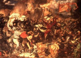
At the end of 14th century, the Polish King Kazimerz Wielki started building fortresses in an attempt to prevent further Teutonic conquests. One of the castles was located in Złotoria, at the confluence of the Drwęca and the Wisła rivers. In 1409, the Teutonic Knights assaulted the castle, precipitating the Great War. This ultimately lead to the great victory over the Teutonic Order at Grunwald on 15th July 1410. The victor, King Władysław Jagiełło forced the Teutonic Knights to leave the left bank of the Wisła river and to destroy their castle in Nieszawa. To secure Polish rule, he also built a castle in Dybowo – just across the river from Toruń.
The harsh rule of the Teutonic Knights and the resulting wars postponed the previously promising and rapid development of the region for more than half a century. The revival of Toruń and the surrounding region began after the Second Toruń Peace Treaty of 1466 which restored Pomorze (Pomerania) and the Chełmińska Land to the Polish Kingdom. Toruń earned the status of an independent royal city owning a large number of villages, farmsteads and forests situated within an extended vicinity. The city flourished, gaining its wealth primarily through river trade. It was famous for its craftsmen, artists, architecture and science. Known for its religious tolerance and high culture, it drew people from all over Europe. These new inhabitants brought with them skills and wealth - substantially contributing to even greater prosperity for both the city itself and the surrounding lands. The cultivation of the Wisła river valley was first started by Dutch settlers, the so called “Olenders”, as well as the Germans and Scots. Their characteristic homesteads and cemeteries can be toured even today. The area’s multicultural population included also Jews, Lithuanians, Armenians, Swedes and many others.

Sadly, in the centuries to come, Toruń and the surrounding region were to share not only the triumphs, but also the tragedies and almost endless series of destructive wars experienced by the country as a whole. The misery was made even worse by various plagues, one of them being the epidemic of the Black Death. At the beginning of the 18th century, this horrific disease took a toll of about 5 thousand deaths in Toruń alone and the number of fatalities in the neighboring area amounted to a third of the entire population! Due to all these dramatic events, the population of Toruń dropped suddenly from 35.000 inhabitants in the 17th. century to 6.000 in the 18th. century. The population of the region only reached its previous level at the beginning of the 20th century.
The period of the country’s partition between the Russian, Prussian and Austrian empires, at the end of 18th century resulted in subsequent gradual division of these lands. The city of Toruń and the adjoining terrain were incorporated into Prussia after the second partition in l793 and the Dobrzyńska Land was taken by the Prussians after the third partition of 1795. An aggressive policy of Germanization and severe suppression of Polish culture followed the arrival of new colonists. After the fall of the Duchy of Warsaw in 1815, provisions of the Congress of Vienna divided Polish lands again. The division of the country was best symbolized by the village of Lubicz - its upper part (Lubicz Górny) being ruled by the Russian Empire with the lower part (Lubicz Dolny) being governed by the Prussians. Two nearby rivers, the Drwęca and the Tążyna played important historic roles, marking the boundaries between the two invaders.
The period of partition caused a dramatic discrepancy in the level of development of the lands under foreign rule. The areas located on the periphery of the great Russian Empire, far from larger settlements and major transport routes, soon began to present a landscape of poor, provincial villages, modest aristocratic manors, and a few colonial settlements. People tried to support themselves mostly by cutting and selling wood and through charcoal production. In the early 1830’s, this grim situation was additionally exacerbated by the destruction inflicted by the Russian army on their way to suppress the November Insurrection. The troops also brought cholera to the region, which together with recurrences killed about a fourth of the population of this immediate area.
A period of relative prosperity finally began late in the second half of the 19th century. The modernization of agriculture and industry led to increased productivity. Sawmills, brickyards, oil-pressing mills, dairies, breweries and distilleries began to proliferate. Also, local craftsmen started to prosper. Trade, although often of a black market nature, was brought about by the short distance to the border. Main villages, with the biggest one being Czernikowo - created centers of local commercial activity hosting agricultural associations, new schools, veterinary, doctor and midwife offices – which were a rarity in rural areas at that time.
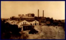
The lands under German rule, on the other hand, developed more intensively and in a different way. Initially, still overshadowed by the city of Toruń, which was turned into a border fortress, they slowly, yet systematically started to undergo changes implemented by "the Prussian way to capitalism". By the end of the 19th century, local agriculture reached an impressive level of productivity. This was accompanied by the development of processing industries including dairies, mills, slaughterhouses, breweries and distilleries. In 1882, the sugar factory in Chełmża, one of the biggest of its kind in Europe, began operations.
The rapid development of the railway network enabled the transport of regional products throughout the German market, contributing to the economic advancement of this area. So did the reviving development of the city of Toruń. The need for modernization of the Prussian fortress also helped the local economy - the whole area benefited from overall growth.

After regaining her long desired independence at the beginning of 1945, the mutilated country had to confront a whole host of problems. Most infrastructure was virtually non-existent – what was left behind and not stolen was at least partially destroyed. Even food supplies were exhausted by the German and Russian armies. Waves of people moving in and out were flooding through the whole country. The implications of a completely new political system also caused much turbulence. Massive changes in ownership – expropriations and nationalizations – and an official ideology were beginning to dominate the new arrangement. Many aristocratic domains were turned into state-owned agricultural farms – known as PGR (Państwowe Gospodarstwo Rolne). Also, a rapid industrialization process was initiated at this time.
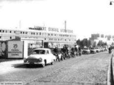
Administratively, Toruń and the District – in its new shape consisting of seven communes - became a part of Bydgoszcz Voivodeship. Despite the problems and changes it had to face, the District managed to reach a reasonable degree of efficiency relatively quickly as measured against the national standard. Various agricultural businesses, industry, trade and services developed in the area, generating increasing employment. Schools, libraries and community centers were established. The modernized road network with the inseparable National Bus Service (PKS) routes provided mobility for the workforce of local industry, growing quickly in the sixties and the seventies.
Following the administrative reform of 1975, districts and communes were abolished and the entire area was included into the newly created Toruń Voivodeship. This arrangement lasted until the end of 1998. The second administrative reform took effect in January 1999 - restoring the Toruń District as a part of the Kujawsko-Pomorskie Voivodeship consisting of eight landed communes and one town.
©2004 by Starostwo Powiatowe w Toruniu. All Rights Reserved. Reproduction in whole or in part without permission is prohibited.